Between the Rising Sun in Pensford and the Stoke Inn, Chew Stoke. Both directions are the same except a short one-way bit in Pensford along Church Street, and another in Chew Stoke where Chapel Lane runs West to East.
Highlights
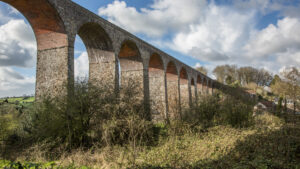
Pensford The village is dominated by the Viaduct. It was built in 1874 to carry the Bristol and North Somerset Railway over the valley of the River Chew. Damaged in the 1968 flood and not now in use, It’s one of what used to be called the ‘burdonsome estate’ – a wonderful name for structures such as bridges, tunnels and viaducts that no longer have a use, but still have to be maintained, as stipulated in the original building contracts. These are now the responsibility of the government. Sustrans has bought up many to maintain them as places to cycle and walk.
Pensford Viaduct
Stanton lane takes you uphill and under the viaduct. It’s very narrow and a bit of a puff, so be alert to traffic and be ready to get close to the hedge. Stop to let traffic pass. As it starts levelling out it changes to Pensford lane until you get to the outskirts of Stanton Drew, when it changes to Upper Stanton. It’s up and down all the way, and very narrow. Single file! The last stretch before Stanton Drew is wider and level – a relief. When you reach the T junction in the village, the ACW takes a left turn.
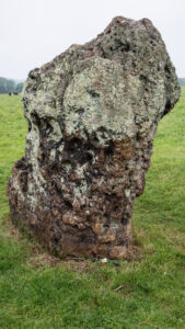
Stanton Drew Stones
Stanton Drew However, you might consider a short detour to the right. Then, taking a right turn after the Druids Arms, you’ll find the famous stone circles – the Great Circle being the second largest in the country after Avebury. Free to enter, wander around and take in the vibe (or watch others doing so). Good information at the English Heritage page here. Beyond the stone circles, at the end of the road you’ll find the curious Roundhouse – which is actually hexagonal. It used to be a toll house, in the days when there were local turnpikes.
OK – back to the cycleway, and we’ll take a left at the T junction onto the Crescent. After 650m the road divides into two and we take the right hand fork before taking a right onto Moorledge Lane. Shortly after the farm on the left, the lane gets narrower and dark with overhanging trees and with a surface that can be rough, it’s not a place to linger. Be alert to traffic and ready to give way. Carry on to the junction with Moorledge Road. Take a right: If you go left, you’ll find yourself at the very famous gastro-pub the Michelin rated Pony and Trap. Carry on down Moorledge Road and at the bottom of the hill turn sharp left into Denny Lane.
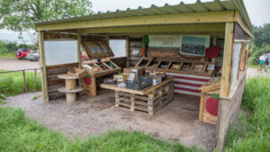
Community Farm
Community Farm Just before the end of Denny Lane, on the left, is the Community Farm, where you can buy local organic produce. The Farm is a community-owned social enterprise, growing and selling organic food through a box delivery service. It’s owned by more than 500 local people. And, every year in August it is the site for Valley Fest – a weekend festival highlighting local organic food, music, workshops, performance, in other words pretty much everything you’d expect from a major festival.
A few yards further on and you reach Wally Lane. The ACW goes to the right, but you could go left and make a short detour to the Salt and Malt cafe and Chew Valley Lake playground. Onto the ACW, and you’ll pass over the dam and the northern end of Chew Valley Lake.
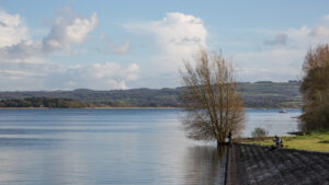
Chew Valley Lake
Chew Valley Lake Owned by Bristol Water, it supplies most of Bristol’s drinking water. The lake is a Site of Special Scientific Interest and was opened by the queen in 1956.
Wally Lane changes into Wallycourt lane before entering Chew Stoke. The area has a surprisingly rich history – going back to the old stone age. On to Bristol Rd, the route goes right, but we’ll turn left to refresh at the Stoke Inn.