Brockley
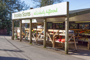
After finishing our coffee and home-made quiche at Brockley Stores, we head back to the intersection with Brockly Coombe. Turning left onto the ACW we enter the pretty little village of Brockley. Brockley was the location of a 300-person Prisoner of War camp during World War II, initially housing Italian prisoners from the Western Desert Campaign, and later German prisoners post the Battle of Normandy.
After passing Brockley Way on the left and then Chelvey Lane on the right, we pass by an interesting company, SolarSense, that specialises in renewable energy – specifically solar power. Then there’s At Play in the Woods – a great place to bring youngsters, and Carmel’s Pottery shop futher along on the right. At the T junction with Chelvey Road take a left and cross over the River Ken. We’ll see more of this river later. Take a left onto Netherton Wood Lane and you’ll soon see the Blue Flame Inn on your right worth a visit if you believe all the rave reviews. After passing the Pub, the road changes its name to the Nailsea Wall Lane. This then runs alongside the River Ken for a while.
North Somerset Levels
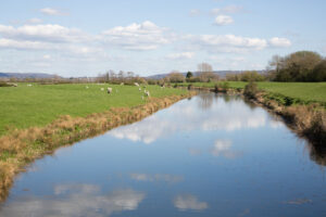
This area is separated from the much larger Somerset Levels by the Mendips to the south. If you look to the right, you’ll see narrow waterways called rhynes – variously spelled. These are drainage ditches, or canals, used to turn areas of wetland at around sea level into useful pasture. There is an extensive network of these, which are artificially fed from time to time to control water levels and reduce the risk of flooding. You can see an example of how this occurs when you get to the Kennmoor Road Turning on the left. Look to your right, and you’ll see the Kenn Pier Sluices. These are used to control the flow of water in the river Kenn, which can flow in either direction, depending on the conditions. Almost all the local waterways have been modified or are man-made. The other side of the sluices leads to a large rhyne called the Blind Yeo, to which the other rhynes are connected. At the blind end of this, at the Severn Estuary, are the main sluices that control the water level. Make a note to look up the history of this area – it’s fascinating.
Past the sluices, the road changes to Davis Lane and we take the first right into ManMoor Lane. This is a dead-straight road that will eventually lead you to Clevedon.
Detour: Half-way along, at the right turn onto Cook’s Lane, the road changes to Court Lane. If you turn left here, onto Moor Lane, you’ll get to the Clevedon Craft Centre, http://www.clevedoncraftcentre.co.uk/.
Onwards, and over the M5 motorway and the Land Yeo river, left at Tickenham Road and into Clevedon. We won’t stop in Clevedon, but at the second roundabout, turn right onto the Portishead Road – the B3124. After a couple of minutes, turn right onto Nortons Wood Lane. This will take us to the Black Horse Pub. It’s a lovely shaded cycle, but it’s narrow, and the road surface is often poor, so look out for potholes. This is a horse-riding area, and you’re likely to meet horses on the lane. Slow down if you do. We’ll pass by the Golden Horse Equestrian centre shortly, followed by the Clevedon Riding Centre. This may be an interesting place to drop in to, if you fancy sitting on a different type of saddle. The road name changes to Clevedon Lane and we carry on until we get to a little wiggle in the road and a turning to the right, which we don’t take. But we could.
Detour: It’s a short path to St Michael’s Church, which is in the care of the Churches Conservation Trust and is usually open on Sundays, 10:30 – 17:00, June to September. At other times the key is available from The Black Horse Inn, which is our last stop just around the corner.
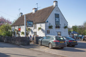
Black Horse Pub – the Kicker
The pub was built on the edge of salt marsh to serve the needs of the local mining community and The Black Horse name is believed to be derived from the pit ponies and the horses that drew the coal to Portishead for shipping. The pit was at the end of the pub garden.